App Lets Outdoor Adventurers Relive Their Experiences Using 3D Videos with Esri Maps
3D Virtual Tours of Cycling Trips and Runs Come Alive on Esri World Imagery Basemaps
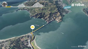
An image from this Relive video shows the route taken during a cycling trip in San Francisco, California.
Are you a cyclist or runner who wants to relive your athletic adventures or share the experience with friends, relatives, or the public? Thanks to a new, free app from a Netherlands-based company, your rides and runs can now be shared via virtual 3D video tours that display the route you took on an Esri World Imagery basemap.
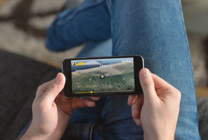
The Relive app combines performance tracking data from cyclists or runners with Esri digital maps and makes a short animation video in 3D that shows about a minute's worth of highlights of the athlete's treks. The animation includes the route traced in yellow on the basemap, metrics such as terrain elevation and the length and average speed of the ride or run, and popups with photographs that were taken during the activity.
The app was developed by the startup Relive, which creates 3D video stories of bike rides and runs using GPS data collected from its users' tracker apps, such as Garmin Connect and Strava, and their personal photographs. Relive currently has 1.2 million users around the world.
"People love to share [the videos] with their family and friends," said Joris van Kruijssen, who cofounded Relive with developers Lex Daniels and Yousef El-Dardiry.
Daniels, van Kruijssen, and El-Dardiry came up with the idea for the Relive app during a bike trip in the Canary Islands in 2016. "We were cycling in Tenerife and figured it would be amazing if there was an app to capture our cycling holiday in a movie," said El-Dardiry, who is also Relive's technical lead.
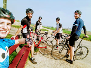
The Relive team includes (from left to right) Ralf Nieuwenhuizen, Yousef El-Dardiry, Joris van Kruijssen, Ronald Steen, and Lex Daniels. Not pictured are Thomas Meijers and Jochem Lugtenburg.
While van Kruijssen, Daniels, and El-Dardiry were using the Strava app to record performance metrics on their rides in Tenerife, the three friends realized something was missing: the visual aspect of their adventures. "It didn't fully capture the experience we had—the nice views, discovering the terrain, and the fun we had. We saw a great opportunity," van Kruijssen said.
Talk soon turned to action. After fleshing out the idea during a barbecue in Tenerife, Daniels and El-Dardiry began writing code, and the app started to take shape later the same day.
Back home in the Netherlands, they created what van Kruijssen called "a good working prototype" within two months and shared it with a few friends. "After a week, a thousand people were using our app," he said.
Today, Relive employs a team of seven people and continues to refine its mobile app, available for download from Google Play or the Apple App Store. The app takes activity-tracking data from apps such as Strava, Garmin Connect, Endomondo, and Polar Flow and maps it on satellite imagery from the World Imagery basemap, which Relive obtained from Esri Netherlands. (Users who sign up for Relive accounts give Polar Flow, Endomondo, Strava, and Garmin Connect permission to share their data with the Relive app.)
During the app development phase, El-Dardiry searched for digital map technology to visualize the adventures. He found Esri's World Imagery basemap in the Living Atlas of the World to be a great fit with the app.
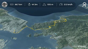
An image from this video displays statistics about a cycling trip, including the distance ridden in kilometers and how long the ride took in hours and minutes.
"We wanted to give everyone the opportunity to create a beautiful video of their adventures, so it was important to find a high-quality map with global coverage," said El-Dardiry. "Esri's Living Atlas of the World was the best solution. And the involvement of Esri is great. They understand the unique needs and challenges of our startup and are always thinking of how they can help us."
During a recent trip to San Francisco, California, van Kruijssen, an avid bike rider, said he tracked his performance metrics as he cycled across the Golden Gate Bridge to Marin County. Within a half hour after his trip, he had used the Relive app to create a video of the journey to send to his mother in the Netherlands. "I immediately shared it with my mom to show her what great views I had," he said.
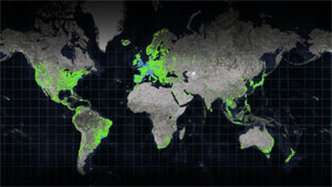
This map, created by Relive and Esri Netherlands, shows where cycling, running, and hiking videos have been made globally. Green symbolizes cycling, blue symbolizes running, and purple symbolizes hiking.
Relive is already a success, with more than 200,000 new videos being made each day around the world including from countries such as South Korea and Brazil. The company recently launched a premium service for paying members called Relive Club, which lets users do more with their videos such as add music.
Maps, however, are a staple in the app. And because Esri's digital maps are scalable, the Relive founders feel confident that their company can continue to grow.
"Every adventure starts with a map," El-Dardiry said. "We want to provide people with the opportunity to relive their adventures, whether they're cycling, hiking, running, skiing, or going on a road trip. It's great to see our idea spread globally…and it's just the beginning of our adventure."
Watch the video of a cycling trip created with the app or make your own virtual tour at Relive.

No hay comentarios:
Publicar un comentario